Why visit
The Hanyangdoseong (한양도성) city wall trail is the main reason to come. The restored granite blocks follow the ridgeline from Changuimun Gate (창의문, Jahamun) to Hyehwamun Gate (혜화문), with intact battlements, guard posts, and views down into both the old city and the modern one. The juxtaposition — sixteenth-century stone fortifications with the Seoul skyline directly behind — is genuinely striking and unlike anything else in the city.
Because access was restricted until recently, the area feels noticeably quieter than Inwangsan or Naksan. You will share the trail with Korean hikers and the occasional military checkpoint reminder, but not with tour bus crowds. It is the one mountain in Seoul where you can walk for an hour and feel like you have the ridge largely to yourself.
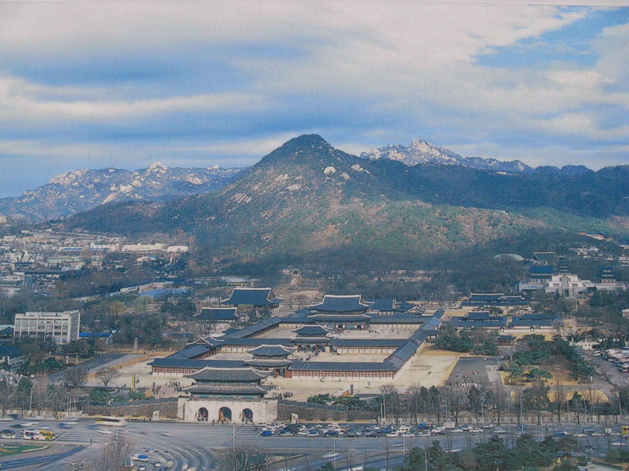
The views south into the old Joseon capital — Gyeongbokgung Palace, Bukhansan behind you, the dense tiled rooftops of Jongno below — are the best single-frame summary of what Seoul actually is: a very old city that kept growing around its original bones.
Getting there
The most common starting point is Changuimun Gate (창의문/자하문). From central Seoul, take bus 1020, 7022, or 7212 to the Changuimun stop (창의문) in Buam-dong. From Gyeongbokgung Palace, the walk to Changuimun is about 20–25 minutes on foot up the hill — straightforward and well-signposted.
Alternatively, take Line 3 to Gyeongbokgung Station (경복궁역), exit 3, and walk north past the palace to pick up the Bugaksan trail markers. The Hyehwamun Gate (혜화문) end connects to Line 4 at Hansung University Station (한성대입구역).
Note that you need to register at the trail entrance checkpoint — bring your ID (passport for foreigners). The process takes 2–3 minutes and is straightforward.
At a glance
Elevation: 342 m Difficulty: 1–2 / 5 — gentle ridge walk along restored city wall Typical duration: 2–3 hours Changuimun to Hyehwamun one-way Best season: April (cherry blossoms below), October–November (foliage) National park: No (Seoul city-managed historic site) Entry fee: Free; ID check required at trail entrance Nearest transit: Bus to Changuimun; or walk from Gyeongbokgung Station (Line 3)
Safety
ID required: Bring your passport or ARC card. The checkpoint at the trail entrance turns people away without ID — this is not optional.
Military area: Bugaksan remains within a restricted zone. Stay on marked trails. Photographing certain facilities is prohibited; signs clearly indicate where. Follow instructions from any uniformed personnel without argument.
The trail is a paved and stone-stepped path — not technical. Main hazards are slippery stone in wet weather and ice on north-facing sections in winter. Normal hiking shoes are fine spring through autumn; traction aids help in January–February.
Emergency: 119. Cell coverage is good across the entire trail given the urban setting.
Map
Food on the trail
Buam-dong (부암동), the neighbourhood at the Changuimun end, has a good selection of cafes and small restaurants — it is one of Seoul's quieter, more atmospheric dining areas. Worth lingering at after the hike. Expect Korean home cooking (백반), handmade noodles, and several well-regarded coffee shops.
At the Hyehwamun end near Hansung University, there are plenty of cheap and good restaurants catering to university students — Korean staples at fair prices.
On the trail itself, there are no food vendors. The walk is short enough that carrying snacks and water is all you need.
Packing tips
ID (passport or ARC card) — non-negotiable; without it you cannot enter. Water 1 L — the trail is short but sunny in summer. Light layers — the ridge catches wind year-round; bring a windbreaker even in warm weather. Light traction aids January–February — north-facing stone steps get icy. Good walking shoes — no technical gear needed, but the stone steps are uneven.
Best season
March–April: Cherry blossoms in the neighbourhoods below (Buam-dong, Samcheong-dong). The trail itself is bare but the surrounding context is beautiful. Good weather for walking.
May–September: Pleasant ridge walk; summer heat is manageable because the trail is short. Hazy days reduce the view, but the wall itself is the draw.
October–November: Best foliage season. The views south over the old city are especially atmospheric with autumn colour below.
December–February: Cold and occasionally icy. The restricted-access history means fewer winter visitors than other Seoul mountains — sometimes you'll have the wall nearly to yourself on a weekday morning.
Culture & history
Bugaksan was designated the "main mountain" (주산, jusan) of Hanyang — the Joseon capital founded in 1394 — according to the principles of pungsu (풍수, Korean geomancy). The capital's layout was structured around four guardian mountains: Bugaksan to the north, Naksan to the east, Inwangsan to the west, and Namsan to the south. Gyeongbokgung Palace was positioned to face south with Bugaksan directly at its back.
The Hanyangdoseong city wall, originally constructed in 1396–1397 under King Taejo, runs along Bugaksan's ridge. It was built, destroyed, repaired, and extended across the Joseon period and into the Japanese colonial era. The current restored sections represent one of the more ambitious urban heritage projects in Korea — over 13 km of the original 18 km circuit have been restored.
The mountain's recent history is also part of its character. In January 1968, a North Korean commando unit of 31 men infiltrated Seoul via Bugaksan with the mission of assassinating President Park Chung-hee. They were intercepted near Changuimun Gate in a firefight that killed most of the unit and a number of South Korean police and civilians. A bullet-scarred pine tree near the gate has been preserved as a reminder, and the incident explains why civilian access remained restricted for the next four decades.
Frequently asked questions
›How high is Bugaksan?
Bugaksan rises to 342 m above sea level.
›How difficult is hiking Bugaksan?
The difficulty of Bugaksan is rated 2/5 (Easy). Difficulty varies by trail, so check each course before you go.
›When is the best season to hike Bugaksan?
The best time to hike Bugaksan is Fall.
Have more questions? Ask the community on Connect Korea →