Why visit
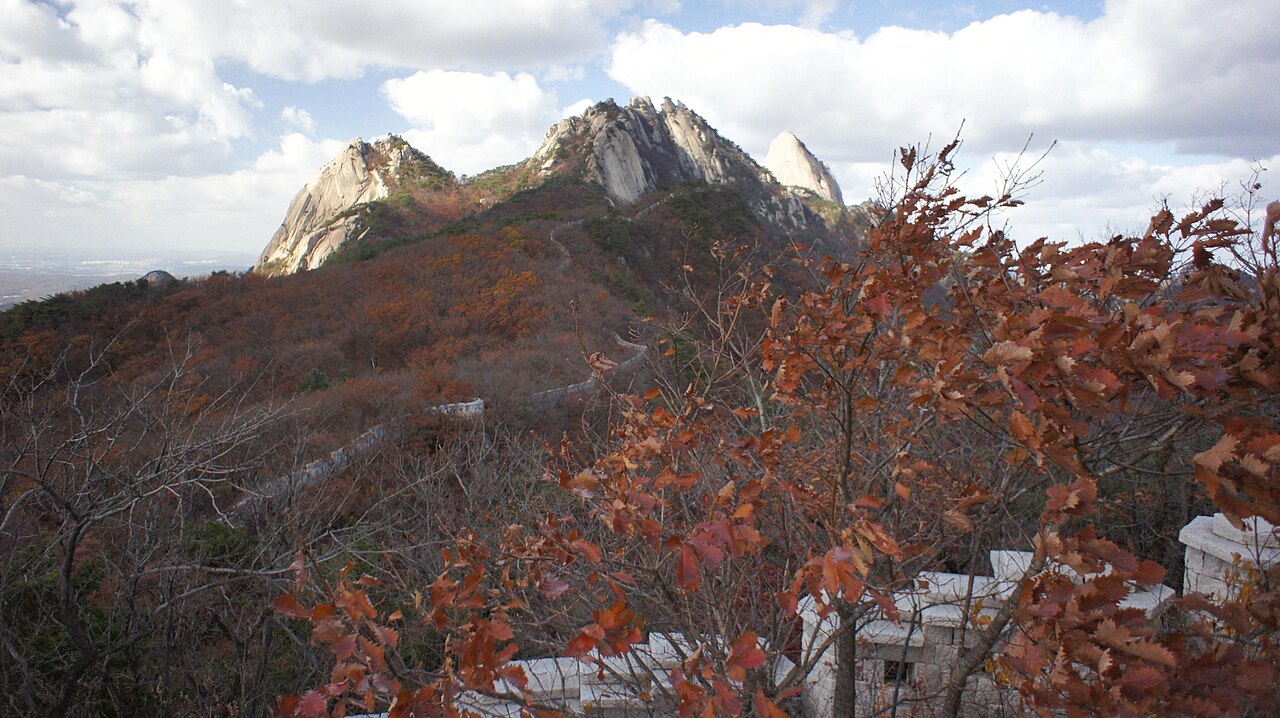
Baegundae (백운대, 836 m) is one of the most satisfying short summit climbs in Korea. The final 200 m involves fixed chains bolted into smooth granite slabs — exposed, slightly airy, and genuinely fun. The summit view takes in the full Seoul skyline to the south and the rolling forested hills toward North Korea to the north. You can be back on the subway in under three hours from central Seoul.
Insubong (인수봉, 810 m) is Korea's premier traditional rock climbing crag. The 200 m granite dome sees climbers on its routes year-round. If you want to watch Korean sport climbers working difficult lines up blank granite, the approach trail to the base of Insubong is a ten-minute walk from the Baegundae trail junction.
The Bukhansanseong fortress (북한산성) walls are one of the park's underrated attractions. Built in 1711 during the Joseon dynasty as a mountain refuge fortress, sections of the stone wall run along ridgelines for several kilometres. Hiking the wall circuit — not the summit — gives a different and historically rich perspective on the mountain.
With 13 temple sites and ruins inside the park boundaries, Bukhansan is as much a cultural landscape as a natural one. Doseonsa (도선사), Hwagyesa (화계사), and Munsubosa (문수보살) are among the active temples that can be visited as part of a hiking loop.
Getting there
Multiple trailheads, all reachable by subway and short bus or walk.
For Baegundae (main summit): Take Line 3 to Gupabal Station (구파발역), then bus 704 or 34 to Bukhansan Ui-dong (북한산 우이동) or the Bukhansan National Park entrance. Alternatively, take the Ui-Sinseol Light Rail (우이신설선) to Bukhansan Ui-dong Station (북한산우이동역) — the terminal station is a 10-minute walk from the Ui-dong trailhead.
For Bukhansanseong area (fortress walls, Daeseo-mun gate): Gupabal Station (Line 3), then bus 704 to Bukhansanseong entrance.
For Dobongsan side (separate summit, same park): see the Dobongsan entry — Dobongsan Station (Lines 1 & 7).
Bus 704 from Gupabal is the most useful single service for foreign visitors targeting Baegundae. Journey time from Gupabal to the park entrance is about 15 minutes. The bus stops on request — press the button as the park entrance sign appears.
At a glance
| Detail | Info |
|---|---|
| Elevation | 836 m (Baegundae); Insubong 810 m, Mangyeongdae 799 m |
| Difficulty | 3 / 5 (Baegundae via Ui-dong — chain sections near top) |
| Typical duration | 4–5 hrs round trip (Ui-dong → Baegundae) |
| Best season | Spring (Apr–May) and autumn (Oct–Nov) |
| National park | Yes — Bukhansan National Park |
| Entry fee | Free |
| Nearest subway | Bukhansan Ui-dong (Ui-Sinseol Line) · Gupabal (Line 3) |
Safety
Emergency: 119. English support: 1330.
Chain sections near Baegundae: the final granite approach requires using fixed chains bolted to the rock. These are perfectly safe in dry conditions but become treacherous when wet. If it has rained, the descent is significantly more dangerous than the ascent. Descend slowly, face the rock, and use both hands.
Winter ice: December through February the upper chains and granite slabs ice over. Crampons or micro-spikes are strongly recommended. Rental is available at shops near the Ui-dong and Bukhansanseong trailheads (₩5,000–8,000).
Seasonal closures: the park enforces closures on erosion-affected slopes in spring (typically April–May) and occasionally during dry spells in autumn. Check the park website or trailhead signage — notices are in Korean.
Crowds: weekend crowds at Baegundae are large. The chain section creates bottlenecks — expect queuing at peak times. Weekday visits or early Saturday starts (before 08:00) are significantly less congested.
Map
Food on the trail
Ui-dong trailhead village (우이동 상가): a well-developed row of Korean restaurants and hiking gear shops runs from the bus/light-rail terminus to the park entrance. 삼겹살 (pork belly), 보쌈 (steamed pork with pickled vegetables), and 막걸리 are the post-hike staples. Several places have picture menus.
Convenience stores: GS25 and CU branches operate near the Ui-dong terminus. Good for pre-hike supplies.
On the mountain: no food is sold above the trailhead commercial zone. Pack at least 1 L water and some energy food. The summit offers no shelter or refreshment.
Near Gupabal Station: the commercial strip around Gupabal has additional restaurant options if you come from that direction. A few cafés have opened catering to the hiking crowd.
Packing tips
- Hiking shoes with grip: the chain sections require friction on smooth granite — trail runners work but road shoes do not.
- Grip gloves: useful on the chains in all seasons, essential in winter for warmth.
- Trekking poles: fine for the lower trails; stow them before the chains.
- Water 1.5 L: no sources above the trailhead.
- Crampons (Dec–Feb): ice on the upper chains is the main winter hazard. Rental at trailhead shops.
- Sun protection: the upper granite ridge has no shade in summer.
Best season
Spring (Apr–May): Azaleas on the lower slopes bloom in April. Pleasant temperatures and the clearest skies of the year. The busiest season overall.
Summer (Jun–Aug): Hot and humid below the tree line. The upper granite is exposed and hot; early morning starts (06:00–07:00) are much better than midday. Thunderstorms can develop quickly in late afternoon.
Autumn (Oct–Nov): Second peak season. Maples turn red and gold in late October against the white granite — the combination makes for strong photography. Dry, stable weather.
Winter (Dec–Feb): Seoul winters are cold and the upper mountain accumulates ice. Crampons needed. Crowds thin substantially. The Bukhansanseong fortress walls under snow are particularly striking.
Culture & history
Bukhansan (北漢山, "North Han Mountain") was the northern guardian peak of Hanyang (Joseon-era Seoul) in the classical geomantic system. The mountain anchored the northern edge of the city's protective ring of four peaks.
Bukhansanseong (북한산성), the mountain fortress, was built between 1711 and 1712 under King Sukjong as a refuge for the royal court in case of invasion. It enclosed an area of about 11 km² with 13 km of walls and 13 gates. The fortress was never actually put to use in battle, but its construction absorbed significant state resources. Substantial wall sections have been restored and are walkable today.
Insubong (인수봉) has a different kind of cultural history: it is where modern Korean rock climbing was born. Climbers began developing routes on its granite face in the 1960s and 1970s, and the crag has been central to Korean climbing culture ever since. The dome's routes range from easy scrambles to severe technical pitches, and the climbing community that uses it is among the most active in Asia.
The mountain also holds a specific place in modern Korean political history: Bukhansan was the site of the 1987 student demonstrations that preceded the June Democracy Movement, which led to constitutional reform and direct presidential elections.
Frequently asked questions
›How high is Bukhansan?
Bukhansan rises to 836 m above sea level.
›How difficult is hiking Bukhansan?
The difficulty of Bukhansan is rated 3/5 (Moderate). Difficulty varies by trail, so check each course before you go.
›Do I need a reservation to hike Bukhansan?
No reservation is needed for the main trails on Bukhansan. Just check trail conditions before you set out.
›When is the best season to hike Bukhansan?
The best time to hike Bukhansan is Fall, Spring.
Have more questions? Ask the community on Connect Korea →