Why visit
The Sinbundang Line runs straight from Gangnam Station to Cheonggyesan Station in 15 minutes. Exit the station, walk five minutes, and you are at the Wonteo (원터골) trailhead. This is one of the cleanest subway-to-mountain connections in the Seoul metro area — faster from Gangnam than Bukhansan or Dobongsan are from central Seoul.
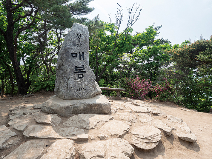
The terrain suits a wide range of people. The ridgeline up to Maebong (매봉) and Manggyeongdae (망경대) has broad, signed paths and no technical sections. Children manage it comfortably. The summit views open up over the Bundang and southern Seoul basin — not as dramatic as Bukhansan but satisfying, and the crowds are thinner than on the north Seoul mountains.
Cheonggyesa (청계사), the Goryeo-dynasty temple at the western base, has operated since the 10th century. The courtyard is free to enter, the stone lanterns are old and genuine, and the setting in the valley below the granite ridge is peaceful. It is an easy detour from the main route — a 30-minute walk from Wonteo via the ridge, then down the western valley.
May brings royal azaleas (철쭉) to the ridgeline in crimson waves, and early April layers cherry blossoms across the lower approach. The mountain has a loyal following of Gangnam and Bundang office workers who climb it on weekday evenings during spring and autumn — a crowd that tends toward competent and fast.
Getting there
Take the Sinbundang Line (신분당선) to Cheonggyesan Station (청계산입구역). From Gangnam Station (Lines 2 & 9) the journey is about 15 minutes. From Sinchon or Hongdae, transfer to Line 2 and ride to Gangnam. From Itaewon, change at Yangjae (양재역, Line 3 and Sinbundang).
The station exit deposits you directly into the Wonteo valley commercial strip. The trailhead is a flat 5-minute walk ahead. No bus needed.
Alternative western approach via Cheonggyesa temple: reachable by bus from Uiwang or Seongnam, but English signage is sparse on this side. Naver Map or Kakao Map navigation is essential.
Last Sinbundang trains run past midnight on both weekdays and weekends — no rush on descent. T-money and credit cards both work on the Sinbundang Line.
At a glance
| Detail | Info |
|---|---|
| Elevation | 618 m (Manggyeongdae area) |
| Difficulty | 2 / 5 — well-graded trails, no technical sections |
| Typical duration | 4–5 hrs round trip (Wonteo → Maebong → Manggyeongdae) |
| Best season | Spring (Apr cherry blossom, May azalea) and autumn (Oct–Nov) |
| National park | No — Gyeonggi / Seoul municipal green zone |
| Entry fee | Free |
| Nearest subway | Cheonggyesan (청계산입구역), Sinbundang Line — 5 min walk to trailhead |
Safety
Emergency: 119. English: 1330 (24 hours).
Trail surface: wooden boardwalks on steeper sections, but granite roots and rock steps become slippery when wet. Trail shoes with grip are advisable even for casual hikers.
Winter ice: shaded sections ice over December through February. Micro-spikes recommended; rental at Wonteo entrance shops (~₩5,000).
Seasonal closures: some slopes close for revegetation (typically March–May). Notices in Korean at trailhead boards — check Naver Map trail status or call 1330.
Wild boar: sightings reported in the forested lower sections. Make noise on quiet sections and do not leave food unattended.
Cell signal: strong 4G/5G throughout including the summit.
Map
Food on the trail
Wonteo valley commercial strip (원터골): a cluster of Korean restaurants between the station and the trailhead. 된장찌개, 파전 (savoury pancakes), and post-hike 막걸리 are the defaults. Most menus are Korean-only; pointing at other tables' food works well enough.
Convenience store: GS25 or CU near the station for pre-hike kimbap, energy drinks, and instant noodles.
On the mountain: no food sold above the trailhead area. Pack at least 1.5 L water and enough food for 4–5 hours before starting.
Allergen note: the trailhead restaurants use doenjang (fermented soybean paste), gochujang, and sesame oil heavily. English allergen communication is unreliable at these small places. Carry a translated allergy card if needed.
Packing tips
- Trail runners or light hiking shoes: no scrambling, but wooden boardwalks and wet granite need grip that road shoes lack.
- Water: 1.5 L; no streams or taps on the main ridge above the trailhead.
- Winter micro-spikes (Dec–Feb): rental at Wonteo entrance (~₩5,000).
- Sun hat and layers: the upper ridgeline is exposed.
- Trekking poles: optional for knees on descent; no sections requiring them to be stowed.
Best season
Spring (late Mar–May): Cherry blossoms on the lower approach in late March to early April. Royal azaleas (철쭉) on the upper ridgeline peak in early to mid-May — often the busiest weekend of the year at Cheonggyesan. Ideal temperatures and clear skies.
Summer (Jun–Aug): Dense forest canopy keeps the lower trails cooler than exposed ridge mountains, but humidity is high. Good for early-morning weekday trips; avoid the peak holiday weekends in late July and August.
Autumn (Oct–mid-Nov): Maple and oak foliage peaks in the last week of October. Ridgeline views south toward Bundang and north toward Seoul are sharpest in clear autumn air.
Winter (Dec–Feb): Snow is infrequent but striking when it falls. Trail board ice is the main hazard. Micro-spikes advised. Much less crowded than spring and autumn.
Culture & history
Cheonggyesan (淸溪山, "Clear Stream Mountain") takes its name from the cold boulder-fed streams on its northern and western slopes — a name that captures what Koreans have long associated with the mountain: coolness, clarity, and distance from the noise of the city.
Cheonggyesa (청계사), the temple at the western base, was founded during the Goryeo dynasty (918–1392) and received royal patronage from several kings. The main hall was rebuilt during the Joseon period and the courtyard contains stone lanterns from different eras. The temple remained active through the Japanese colonial period and continues as a working Buddhist monastery. No entry fee; visitors are welcome.
The mountain is connected to the personal history of Jo Gwang-jo (조광조, 1482–1519), the reformist Neo-Confucian scholar-official of King Jungjong's court. He is said to have retreated here for study and contemplation. Several hermitages along the trails bear references to his presence. His later execution by political enemies made him a symbol of scholarly integrity, and the association with Cheonggyesan gives the mountain a melancholy undercurrent in Korean historical memory.
For contemporary Seoul, Cheonggyesan carries a specific social identity as the "office workers' mountain" of the Gangnam and Bundang corridor — close enough for an after-work hike, demanding enough to count as exercise.
Frequently asked questions
›How high is Cheonggyesan?
Cheonggyesan rises to 618 m above sea level.
›How difficult is hiking Cheonggyesan?
The difficulty of Cheonggyesan is rated 2/5 (Easy). Difficulty varies by trail, so check each course before you go.
›When is the best season to hike Cheonggyesan?
The best time to hike Cheonggyesan is Fall, Spring.
Have more questions? Ask the community on Connect Korea →