Why visit
The subway delivers you to Dobongsan's park gate without a bus transfer — step off Line 1 or Line 7, walk five minutes, and you're in the national park. No other mountain in Korea matches that. For visitors without a car or a Korean SIM, this directness matters.
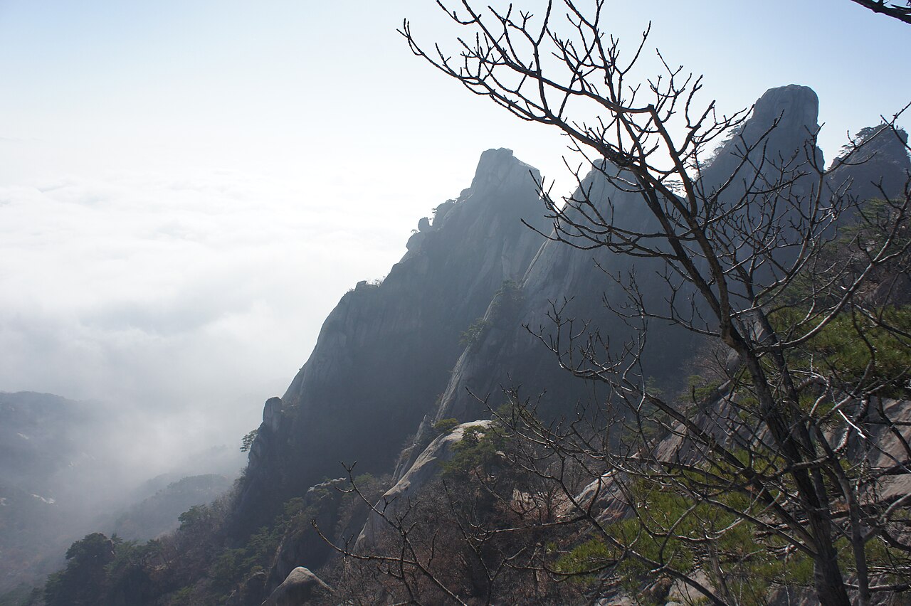
The granite spires are the visual draw. Jaunbong (740 m), Manjangbong (718 m), and Seoninbong (708 m) rise in a tight cluster that looks jagged even from downtown Seoul. The final approach to Jaunbong and Manjangbong uses iron rungs bolted into sheer rock — exposed, exciting, and technically demanding enough to feel like a real achievement without requiring climbing equipment.
Seoninbong itself is a year-round rock climbing venue. Routes run up the clean granite face from easy slab climbs to severe trad lines. If you want to watch Korean climbers at work on a weekend morning, the base of Seoninbong is the place.
The Dobong Valley below the spires has a different character: Buddhist temples (Mangwolsa, Cheonchuksa) in cool ravines beside streams, forest trails shaded even in summer, and a contemplative atmosphere that stands apart from the summit-focused crowds above.
Getting there
Dobongsan Station is served by Line 1 (dark blue) and Line 7 (olive). From central Seoul (City Hall, Seoul Station), take Line 1 northbound — about 40 minutes direct. From Gangnam or Hongdae, take Line 7 northbound — around 50 minutes. From anywhere else, one transfer reaches one of these lines.
Exit the station and walk straight ahead. The national park entrance and the Dobong Valley trailhead are within 5 minutes on foot. No bus, no taxi, no navigation needed.
Last trains run past midnight (around 01:00 on weekdays), so a late descent is not a problem. T-money or Cashbee card works on all Seoul metro lines. Naver Map gives real-time transfer routes from any starting point.
At a glance
| Detail | Info |
|---|---|
| Elevation | 740 m (Jaunbong); Manjangbong 718 m, Seoninbong 708 m |
| Difficulty | 3 / 5 — iron rungs and rope sections near the summit spires |
| Typical duration | 4–6 hrs round trip (Dobong Valley main route) |
| Best season | Spring (Apr–May) and autumn (Oct–Nov) |
| National park | Yes — Bukhansan National Park (northern section) |
| Entry fee | Free |
| Nearest subway | Dobongsan Station (Line 1 / Line 7) — trailhead at exit |
Safety
Emergency: 119. English: 1330 (24 hours).
Iron rungs: the final approach to Jaunbong and Manjangbong has iron rungs bolted into sheer granite. Stow trekking poles before you reach the chain sections — both hands are required. Wet granite is genuinely slippery; descend facing the rock.
Winter ice: December through early March, ice accumulates on the upper chains and slabs. Crampons or micro-spikes are strongly recommended. Rental at shops near the station exit (₩5,000–8,000).
Seasonal closures: Bukhansan National Park closes certain slopes in spring and early summer for revegetation. Check knps.or.kr or Naver Map trail status before visiting — signage is in Korean only.
Cell signal: strong across the valley and most of the mountain. LTE is reliable even near the summit.
Map
Food on the trail
The commercial strip outside Dobongsan Station exit is one of the best-developed of any Seoul mountain trailhead. Korean BBQ, 된장찌개, and 막걸리 houses line the street — locals pack the tables after a weekend hike. Menus are almost exclusively Korean; photos and pointing at neighbouring tables both work reliably.
Convenience stores (GS25, CU) inside or near the station cover pre-hike supplies: triangle kimbap, energy bars, drinks.
On the mountain: no food or drink sold above the trailhead commercial zone. The temples (Mangwolsa, Cheonchuksa) do not sell food. Pack everything before you start — at least 1.5 L of water.
Packing tips
- Hiking shoes with grip: smooth-soled shoes don't work on the granite rung sections.
- Grip gloves: useful year-round on the fixed chains; essential in winter.
- Trekking poles: fine for the valley approach, stow before the chain sections.
- Water: 1.5 L minimum — no sources above the trailhead.
- Crampons (Dec–Mar): ice on the upper chains is the primary winter hazard. Rental near station exit.
- Sun protection: the exposed upper ridge has no shade in summer.
Best season
Spring (Apr–May): Azaleas cover the lower slopes in mid-April. Valley trails are lush, temperatures comfortable (8–18 °C). Busy on weekends — Golden Week (late April–early May) is the peak.
Summer (Jun–Aug): Hot and humid below the tree line; the shaded valley stays cooler than the ridgeline. Typhoon season (July–September) brings sudden heavy rain — avoid the upper chain sections in wet conditions.
Autumn (Oct–Nov): Peak foliage in late October. Red and gold maples against white granite under blue sky — the defining Dobongsan image. Dry, crisp air. Book transport back early on foliage-peak weekends.
Winter (Dec–Feb): Snow on the spires is striking. Ice on the upper chains is the main hazard — crampons essential. Crowds thin sharply; the valley has a quiet, contemplative character in winter.
Culture & history
Dobongsan (道峰山) — the 道 character suggests a path or way, and the mountain has long carried associations with spiritual seeking and retreat from the world.
Mangwolsa (망월사, "Moon-Gazing Temple") sits high in the valley, traditionally founded in 639 CE during the Silla dynasty by the monk Haemyeong. The name — gazing at the moon from the mountainside — points to a deep current in Korean mountain culture, the hermit tradition of withdrawal and contemplation.
Cheonchuksa (천축사, "India Temple") takes its name from 천축 (天竺), the classical Korean rendering of India. The temple's aspiration was to embody the spiritual homeland of Buddhism — an ambition embedded in its name since the Unified Silla period.
Seoninbong (선인봉, "Immortal Peak") references the Taoist immortals — the seonin (仙人) who dwell in mountain fastnesses in East Asian mythology. This spire has been regarded as their habitat since at least the Joseon era. Joseon scholars hiked Dobongsan as a form of self-cultivation and wrote about it in the yugi (遊記) travel essay tradition.
Frequently asked questions
›How high is Dobongsan?
Dobongsan rises to 740 m above sea level.
›How difficult is hiking Dobongsan?
The difficulty of Dobongsan is rated 3/5 (Moderate). Difficulty varies by trail, so check each course before you go.
›Do I need a reservation to hike Dobongsan?
No reservation is needed for the main trails on Dobongsan. Just check trail conditions before you set out.
›When is the best season to hike Dobongsan?
The best time to hike Dobongsan is Fall.
Have more questions? Ask the community on Connect Korea →