Why visit
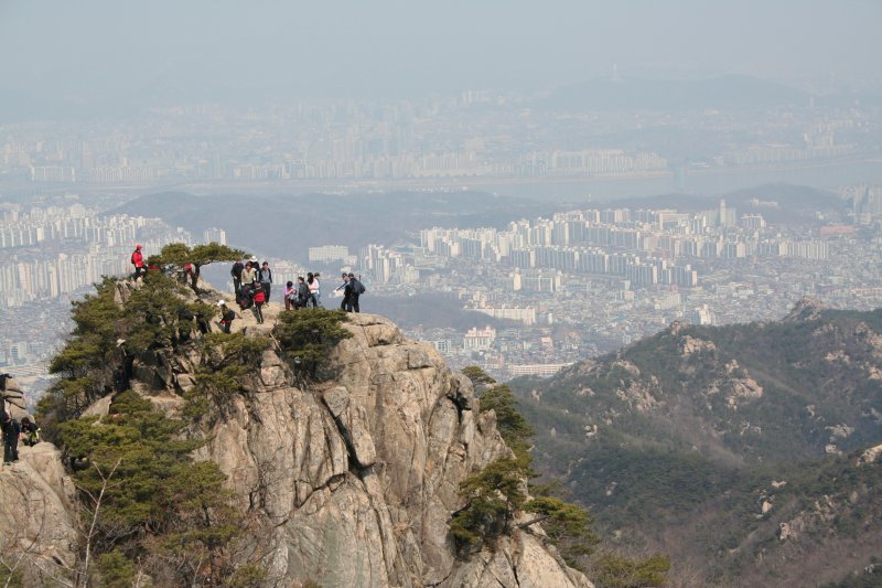
Gwanaksan punches well above its elevation. The main route from Gwanak Station climbs through dense forest to the rocky upper ridge, where fixed ropes and chains guide you over granite outcrops. The summit (연주봉 or Yeonjubong) has a radar dome and sweeping views north over the Han River and south toward Anyang. The feeling of exposure and effort is greater than the 632 m suggests.
The mountain is the backyard of Seoul National University and has an unusual concentration of students among its weekday hikers — you are as likely to share the trail with a researcher taking a lunch break as with a retired couple. This gives it a different social atmosphere from the older hiking crowds of Bukhansan.
Yeonjuam hermitage (연주암) near the summit is a small, active Buddhist temple perched dramatically on the cliff face with views over the city. The rock-carved Buddha figures at Yonghwasa (용화사) on the northern approach are an easily missed but historically interesting stop.
For the adventurous, Gwanaksan's ridgeline extends west through Samseongsan and east to Cheonggyesan — experienced hikers do the full ridge day on a long summer day.
Getting there
The main trailhead is directly accessible from the subway. Take Line 2 to Nakseongdae Station (낙성대역) or Gwanak Station (관악역), then follow the trailhead signs — the park entrance is about a 10-minute walk from either station. Gwanak Station (exit 5) is slightly closer to the main Yeonjuam summit trail.
Alternatively, Line 4 to Seoul National University Station (서울대입구역) connects to the eastern approach trails through the university campus — slightly longer but passes through interesting campus architecture.
From Gangnam, take Line 2 westbound from Gangnam Station to Nakseongdae (about 20 minutes). From central Seoul (Dongdaemun), Line 2 westbound takes about 30 minutes. No bus transfer needed.
Return options: you can descend the same way or exit via Anyang (안양) on the southern side, adding variety. The Anyang side has buses to Anyang Station (Line 1 and Line 4 interchange).
At a glance
| Detail | Info |
|---|---|
| Elevation | 632 m (Yeonjubong / Gwanaksan summit) |
| Difficulty | 3 / 5 — rope and chain sections on main ridge |
| Typical duration | 4–5 hrs round trip (Gwanak Station → Yeonjuam → summit) |
| Best season | Spring (Apr–May) and autumn (Oct–Nov) |
| National park | No — Seoul / Gyeonggi provincial park |
| Entry fee | Free |
| Nearest subway | Gwanak Station (Line 2, exit 5) · Nakseongdae Station (Line 2) |
Safety
Emergency: 119. English support: 1330.
Rope and chain sections: more extensive than Bukhansan or Dobongsan. Several sections require using fixed ropes on steep granite, and on descent these become the primary hazard. Wet granite after rain is significantly more dangerous — if the forecast shows rain, plan to avoid the summit ridge. Do not attempt in flip-flops or flat-soled shoes.
Winter ice: Gwanaksan's terrain freezes hard December through February. Crampons are essential on the upper rocky sections. Without them, the descent from the summit is dangerous enough to warrant turning back.
Heat in summer: the south-facing granite slopes absorb and radiate heat in July and August. Heat exhaustion is a real risk for hikers who start midday in summer. Start before 08:00 or after 17:00 to avoid the worst of it.
Trail forks: Gwanaksan has a more complex trail network than most Seoul mountains. Naver Map with the hiking overlay (등산로 보기) is useful to stay on your intended route.
Map
Food on the trail
Gwanak Station and Nakseongdae Station exits have small clusters of convenience stores and basic Korean restaurants — solid enough for pre-hike supplies. The Sillim-dong neighbourhood one stop east on Line 2 has better food density if you want a proper meal before hiking.
On the mountain: no food is sold on the trail. Yeonjuam hermitage has a small outdoor vending area with drinks in summer. This is the only option above the trailhead.
Post-hike in Nakseongdae: the 순대국밥 (sundae soup) and 설렁탕 (ox bone soup) restaurants near Nakseongdae are popular with returning hikers. Portions are generous and prices are in the ₩9,000–13,000 range.
Packing tips
- Footwear: hiking shoes or trail runners with grip are essential — the rope sections on smooth granite require sole friction that casual shoes lack.
- Trekking poles: stow them before rope sections; useful on the longer forested approach and descent.
- Water: 1.5 L; no sources on the upper trail.
- Crampons (Dec–Feb): essential for the upper rocky sections in winter.
- Sun protection: the south-facing granite bakes in summer. Hat and sunscreen for the ridge sections.
- Light gloves: useful on the metal ropes and chains in all seasons, essential in winter.
Best season
Spring (Apr–May): Best for the lower forested trails. Azaleas bloom in April; temperatures are cool and comfortable on the upper granite.
Summer (Jun–Aug): The mountain is technically hikeable but the south-facing slopes are hot. Dawn hikes (start at 05:30–06:00) are the strategy of regulars in July and August.
Autumn (Oct–Nov): Strong colours on the mixed woodland lower slopes. The upper granite under blue sky in crisp air is the most photogenic version of this mountain.
Winter (Dec–Feb): Gwanaksan is technically challenging in winter due to extensive ice on the rocky sections. Worth doing for experienced winter hikers; genuinely dangerous for unprepared visitors.
Culture & history
Gwanaksan (冠岳山) means "Mountain of the Official's Cap" — the ridgeline silhouette resembles a gat, the horsehair hat worn by Joseon-era officials, and the name has been in use since at least the early Joseon period.
In the Joseon geomantic system, Gwanaksan was the southern guardian peak for the entire Hanyang basin, distinct from Namsan's role as the guardian of the city proper. It was treated as a sacred mountain and hunting and logging were periodically prohibited on its slopes by royal decree.
Yeonjuam (연주암), the hermitage near the summit, is believed to have been founded during the Silla period and is one of the oldest surviving religious sites in the greater Seoul area. The name yeonju (戀主) means "longing for one's lord" — a name associated with a story of loyalty and exile.
In the modern era, Gwanaksan became culturally associated with Seoul National University, which built its main campus at the mountain's northern base in 1975. The mountain served as a backdrop for student protest movements through the 1980s, and the trails are still dotted with memorial markers from that period.
Frequently asked questions
›How high is Gwanaksan?
Gwanaksan rises to 632 m above sea level.
›How difficult is hiking Gwanaksan?
The difficulty of Gwanaksan is rated 3/5 (Moderate). Difficulty varies by trail, so check each course before you go.
›When is the best season to hike Gwanaksan?
The best time to hike Gwanaksan is Fall.
Have more questions? Ask the community on Connect Korea →