Why visit
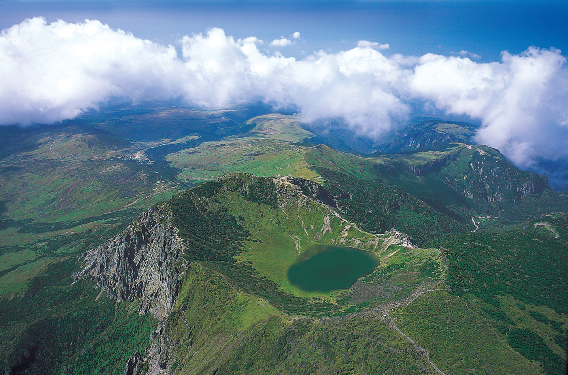
Hallasan is the only mountain in Korea where you stand above the clouds and look down at the sea. On clear winter mornings, the summit crater lake (Baengnokdam, 백록담) sits in still blue silence while cloud fills the valleys below and the coast is a distant shimmer. That view is genuinely unlike anything else on the peninsula.
The volcanic geology makes Hallasan ecologically distinct. The mountain was formed by lava flows over millions of years, and the result is a landscape of parasitic cones (오름, oreum), lava tubes, and oxidized red basalt soil that looks nothing like the granite peaks of the mainland. Over 1,800 plant species have been recorded here, including many found nowhere else in Korea. The dwarf yew forest on the upper slopes is particularly strange and striking.
There are two trails to the summit: Seongpanak (성판악, 9.6 km one way) and Gwaneumsa (관음사, 8.7 km one way). Both are full-day affairs with strict cutoff times enforced by rangers. Seongpanak is the more gradual and heavily used; Gwaneumsa involves steeper sections and a creek crossing and feels more like a proper mountain day. The summit is closed when weather deteriorates — this is not rare.
Even without reaching the top, the Eorimok (어리목) and Yeongsil (영실) trails through the sub-alpine meadows and the Yeongsilgiam rock columns are worth the trip. The Yeongsil route is widely considered the most scenic non-summit hiking in Korea.
Getting there
Hallasan is on Jeju Island, which requires a flight or ferry from the mainland. Flights from Gimpo (Seoul) take 55 minutes and are frequent; Jeju Air, Air Busan, and Korean Air all operate the route. Book at least a week ahead in peak season (summer and Chuseok). Jeju International Airport is in Jeju City on the north coast.
From Jeju City to the trailheads by bus:
- Seongpanak (성판악): Bus 181 from Jeju City Bus Terminal, about 40 minutes, ₩1,500. This is the most convenient trailhead.
- Gwaneumsa (관음사): Bus 475 from Jeju City, about 40 minutes, ₩1,500.
- Eorimok (어리목) and Yeongsil (영실): Bus 240 from Jeju City (Jungmun direction), about 50 minutes.
From Jeju Airport, taxi to Seongpanak takes about 35 minutes and costs roughly ₩25,000–30,000. Many hikers combine renting a car at the airport with the mountain trip.
Note: Naver Map works well on Jeju. Kakao T operates taxis on the island. Intercity buses are infrequent on some routes — check real-time arrivals on Jeju Bus Info (jeju.go.kr/bus) before planning return transport.
At a glance
| Detail | Info |
|---|---|
| Elevation | 1,947 m (Baengnokdam crater rim) |
| Difficulty | 3 / 5 (Seongpanak) — long but non-technical; 4 / 5 (Gwaneumsa) |
| Typical duration | Seongpanak: 9–10 hrs return; Gwaneumsa: 8–9 hrs one way |
| Best season | Oct–Nov (autumn); Apr–May (spring); Dec–Feb (snow) |
| National park | Yes — Hallasan National Park |
| Entry fee | Free |
| Summit cutoff | Seongpanak: depart trailhead by 12:00 noon; Gwaneumsa: by 12:00 noon |
| Nearest airport | Jeju International Airport (flight ~55 min from Gimpo, Seoul) |
Safety
Emergency: dial 119. English support: 1330 (24 hours).
Cutoff times are enforced: rangers physically turn back hikers who arrive at checkpoints too late. The cutoff for reaching the summit zone is tied to safe descent times. Do not argue with rangers — departures from Jeju City before 07:00 give you comfortable margin.
Weather closes the summit regularly. Fog, high winds, and ice in winter are the most common causes. There is no guarantee of a summit view even if you reach the top. Check the Hallasan National Park website (hallasan.go.kr) for current trail conditions on the morning of your hike.
Altitude: 1,947 m is not extreme altitude, but people with heart conditions or unmanaged hypertension should exercise caution on the upper sections — the final 2 km of Seongpanak gains elevation quickly.
Winter conditions: ice on the upper trail makes the final approach to Baengnokdam genuinely hazardous without crampons between November and April. The park provides crampons to borrow at the trailhead entrance booths.
Sun exposure: the upper plateau above the tree line has no shade. UV is intense in summer; pack sunscreen and a hat.
Map
Food on the trail
There are no food stalls or shelters on the Seongpanak or Gwaneumsa trails. Pack everything you need before you start — there is nowhere to buy food between the trailhead and the summit.
Seongpanak trailhead: a small convenience store operates near the bus stop. Basic supplies only. Better to stock up in Jeju City the night before.
Jeju City food before the hike: 고기국수 (pork broth noodle soup) at ₩9,000–11,000 is the standard pre-hike breakfast at local restaurants near the bus terminal. Jeju black pork (흑돼지) is the island's most famous food — grilled pork belly from Jeju's indigenous black pig — and most visitors eat it on the evening before or after the hike. Restaurants along Heukdwaeji Street (흑돼지 골목) in Jeju City cluster around ₩18,000–25,000 per person for a full meal.
On the mountain: at the Witseoreum shelter (윗세오름대피소) on the non-summit Eorimok/Yeongsil route, snacks and drinks are sold. This shelter is not on the Seongpanak summit route.
Packing tips
- Water: 2 L minimum. The trail has no water sources between the trailhead and summit.
- Food: enough for a 9–10 hour day. Energy bars, kimbap, or a proper packed lunch.
- Hiking boots with good ankle support: the trail is long but the rocky sections near the summit need grip.
- Crampons (Nov–Apr): essential for the upper trail. Borrowable free at the Seongpanak and Gwaneumsa entrance booths.
- Wind and rain layer: the summit plateau is exposed and can be very cold even on warm lowland days.
- Sunscreen and hat: no shade on the upper mountain. UV is intense in clear weather at this altitude.
- Fully charged phone: no charging points on the trail. Naver Map works offline on Jeju if you download the area map in advance.
Best season
Spring (late Mar – May): Hallasan's cherry blossoms at the lower slopes bloom in late March, about a week before Seoul. The royal azaleas on the mid-mountain trails peak in early May. Clear days with snow still on the summit make for dramatic contrasts.
Summer (Jun – Aug): Hot and humid at low elevation; refreshingly cool above 1,200 m. Heavy rainfall in July and August — Jeju receives more rain than anywhere else in Korea. The summit closes frequently during typhoon season. Worth avoiding peak summer holiday weeks (late July–mid August) if you want a quieter experience.
Autumn (Oct – Nov): The best overall season. Clear, dry skies are reliable, the reds and golds peak in mid-October, and the cloud inversions over the valleys are most frequent in early morning. Most photographs you've seen of Hallasan come from this window.
Winter (Dec – Feb): Snow on the summit is nearly guaranteed from December onward, and Baengnokdam crater lake freezes over. The lower slopes are subtropical and often mild. This is arguably the most dramatic season visually — but trail closures are frequent, crampons are mandatory, and you need to start very early to beat the cutoff time.
Culture & history
Hallasan (漢拏山) means something close to "Mountain that can pull down the Milky Way" — a name that reflects both its height and the mythological reverence Jeju people have always extended to it. The mountain is the physical and spiritual axis of Jeju Island's indigenous culture, which differs meaningfully from mainland Korean culture in language (Jeju dialect was classified as a separate language by UNESCO), spiritual practice, and folk tradition.
In Jeju shamanism (무속, musok), Hallasan is the home of the mountain deity Hallasan Grandmother (한라산 할망), one of 18,000 deities in the Jeju pantheon. The gut (shamanic ritual) tradition on Jeju is more elaborate and better-preserved than on the mainland, partly because the island's relative isolation protected it from some of the Confucian suppression that diminished mainland shamanism during the Joseon dynasty.
The crater lake Baengnokdam (白鹿潭, "White Deer Lake") takes its name from a Taoist legend: Taoist immortals were said to ride white deer to this lake to drink. The lake is sacred in local tradition and was historically off-limits to ordinary visitors — it only became accessible to hikers after the national park was established in 1970.
Hallasan, along with Jeju's lava tube caves and the coastal tuff ring cliffs (성산일출봉 and others), forms a UNESCO World Natural Heritage Site designated in 2007 — one of only a handful of Korean sites to receive this designation.
Frequently asked questions
›How high is Hallasan?
Hallasan rises to 1947 m above sea level.
›How difficult is hiking Hallasan?
The difficulty of Hallasan is rated 4/5 (Hard). Difficulty varies by trail, so check each course before you go.
›Do I need a reservation to hike Hallasan?
Yes. Hallasan lies in a national park area where some sections require advance reservation. Book through the official park site before your trip.
›When is the best season to hike Hallasan?
The best time to hike Hallasan is Fall.
Have more questions? Ask the community on Connect Korea →