Why visit
The pagodas at Tapsa are the main reason people make the trip. Lee Gap-young built them alone across several decades starting in the 1880s — stacking conglomerate stones by balancing weight against weight, no binding agent at all. The tallest are nearly 9 metres. Engineers who have studied them still argue about how they stay up. Walking through the cluster on a winter morning with light snow coming down is genuinely one of the stranger and more memorable things you can do on a Korean mountain.
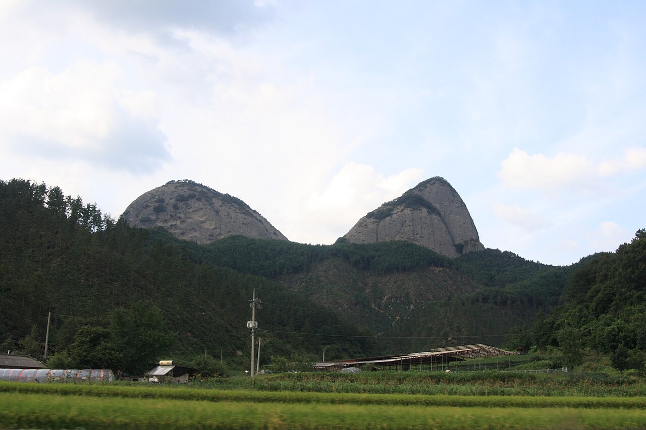
The geology is unlike anything else in the country. Most Korean peaks are granite; Maisan is Cretaceous sedimentary conglomerate — compressed ancient lake-bed material that was pushed up and eroded into these two spires. The rock face is covered in honeycomb weathering pits called tafoni, which give the cliffs a texture that reads as almost sculptural. Worth slowing down to look at closely.
The mountain is a short hop from Jeonju. From Jeonju KTX station you can get to the south entrance in about an hour, do the loop past Tapsa and up to the saddle in three to four hours, and be back in Jeonju for dinner. In early April the access road to Tapsa is lined with cherry blossoms. In winter the snow-covered pagodas look like something out of a folktale. Both are worth planning around.
Getting there
Base yourself in Jeonju. KTX from Seoul Yongsan takes about 1 hour 50 minutes, around ₩27,000–33,000 one way. From Jeonju Bus Terminal (전주시외버스터미널), take an intercity bus to Jin-an (진안) — roughly every 30–60 minutes, about 50–60 minutes, around ₩4,000. From Jin-an, a local bus runs to the Maisan south entrance (마이산 남부) a few times a day, but the schedule is thin and hard to find in English. A taxi from Jin-an Bus Terminal to the south entrance costs about ₩5,000–8,000 and is the easier call. Confirm the last bus or taxi time back to Jin-an before heading up — services stop by early evening.
At a glance
Elevation: 687 m (Ammaibong, highest peak); Sumaibong 681 m Difficulty: 3 / 5 — steep staircase to the saddle; Ammaibong summit closed Nov 1–Apr 30 Typical duration: 3–4 hours round trip, south entrance to Tapsa saddle loop Best season: Early April (cherry blossoms); October–November (autumn foliage); December–February (snow on pagodas) Park status: Maisan Provincial Park (마이산도립공원) — not a national park Entry fee: ₩3,000 adults (confirm at gate)
Safety
Ammaibong summit closure: The higher peak (687 m) is closed every year from November 1 through April 30 to prevent erosion. This is enforced on-site. Sumaibong (681 m) has its own approach trail and stays open year-round.
The staircase to the saddle is steep and exposed. Wet conglomerate is significantly more slippery than it looks when dry. Avoid the upper section in rain or immediately after.
Do not touch or lean against the Tapsa pagodas. Some lean at visible angles and none are structurally reinforced. The site is an active place of worship — treat it accordingly.
Cell signal is generally fine at lower elevations and around Tapsa but can drop on the upper saddle trail. Download an offline map before arriving.
Emergency: 119 (mountain rescue, English relay available). Provincial park office near the south entrance.
Map
Food on the trail
The village at the south entrance has a cluster of restaurants along the road to Tapsa — doenjang jjigae (된장찌개), pajeon (파전), makgeolli (막걸리), simple noodle dishes, around ₩8,000–12,000 a head. Most open around 08:00 and close by late afternoon. Do not count on hot food after 17:00 on weekdays.
Once past the entrance village there is nothing on the mountain. Carry your own water and snacks — the round trip is short but the staircase sections burn energy.
Jin-an town, about 10 minutes by car, has GS25 and CU convenience stores for triangle kimbap, canned coffee, and energy drinks. The jin-an traditional market (진안장) runs on days ending in 2 and 7.
Packing tips
Trail shoes with grip — the conglomerate stairs and rock sections turn slippery when wet; smooth-soled footwear is a bad idea. Wind layer for the saddle — the notch between the peaks funnels wind; useful even in warm weather. Cash — the ₩3,000 entry fee and trailhead vendors are mostly cash-only. Water and snacks — no vendors past the entrance village. Offline map downloaded before arrival — cell signal drops on the upper saddle.
Best season
April: The access road to Tapsa is one of Jeonbuk's best cherry blossom walks, typically peaking in early to mid-April. The mountain emerging from last spring mist as you walk in is genuinely dramatic.
May–September: The valley foliage softens the silhouette in summer. The mountain is open throughout but afternoon thunderstorms are common in July and August.
October–November: Maple and oak colour peaks around late October. The grey conglomerate cliffs against autumn reds and oranges read well visually. Less crowded than the spring cherry season.
December–February: Ammaibong is closed but the walk to Tapsa through snow is worth the trip on its own. The pagodas dusted with snow are the most-reproduced photograph of this mountain. The saddle is exposed and cold — dress for it.
Culture & history
Maisan (馬耳山) has been called different things depending on the season and who was looking. In spring when the peaks push through morning mist, locals called them Doktaebong (돛대봉, Sail Peak). In winter when snow caps them like ink-brushes, Munpilbong (문필봉, Writing Brush Peak). The name Horse Ears stuck.
The hermit who built Tapsa, Lee Gap-young (이갑용), arrived in the 1880s and spent the rest of his life stacking stones. The pagodas were his form of prayer. Whether the stacking method exploits some property of the conglomerate rock's irregular surfaces, or whether it is simply extraordinary patience and precision, remains genuinely debated. He stacked them alone, without an audience, and never explained the method in writing.
Before Buddhism arrived here, Maisan was revered in shamanistic tradition, and Joseon-dynasty records show it was used as a site for state rites. The mountain appears in multiple Joseon-era geographic gazetteers as a site requiring official recognition. The combination — unusual geology, Buddhist devotion, shamanic tradition — makes this one of the more culturally layered smaller mountains in Korea.
Frequently asked questions
›How high is Maisan?
Maisan rises to 687 m above sea level.
›How difficult is hiking Maisan?
The difficulty of Maisan is rated 3/5 (Moderate). Difficulty varies by trail, so check each course before you go.
›When is the best season to hike Maisan?
The best time to hike Maisan is Spring.
Have more questions? Ask the community on Connect Korea →