Why visit
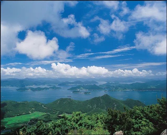
The cable car is 1,975 metres long — among the longest in Korea — and climbs from near sea level to around 400 m. As the gondola rises, dozens of islands across Hallyeo Maritime National Park arrange themselves below you. On a clear day the scale of the southern sea reaches toward Japan. The cable car runs year-round and makes the summit accessible to anyone, including older visitors and families who would not attempt the hiking trail.
The west-facing ridge at the top is one of the better sunset viewing points in southern Korea. Golden hour turns the water between islands into copper. The combination of Tongyeong's skyline, the cable car towers, and the archipelago behind them photographs well in a way that rewards arriving an hour before sunset and staying until the colours fade.
Tongyeong itself adds a lot to the trip. After descending, you can eat Chungmu gimbap (충무김밥 — small plain rolls with spicy marinated squid and radish kimchi) and kkul-ppang (꿀빵 — honey-filled bread) near the cable car terminal, and from November through March fresh oysters (굴) from the harbour fish market. The whole arc — cable car, summit walk, seafood — fits in half a day, with the other half for the city.
Getting there
The easiest base for a day trip is Busan. Direct intercity buses from Busan Seobu Bus Terminal (부산 서부시외버스터미널) to Tongyeong Bus Terminal run frequently and take about 1 hour 40 minutes to 2 hours (around ₩9,000–11,000). From Tongyeong Bus Terminal, a city bus or taxi (about ₩6,000–8,000) gets you to the Hallyeohaesang Cable Car terminal on Mireukdo island in 10–15 minutes.
From Seoul, KTX to Busan takes about 2.5 hours, then the intercity bus to Tongyeong. Alternatively, direct express buses from Seoul Nambu Terminal to Tongyeong run in about 4–4.5 hours. Sacheon Airport (사천공항) receives domestic flights from Gimpo; from there a bus to Tongyeong takes about 40 minutes.
Mireukdo island is connected to the Tongyeong mainland via the Tongyeong Undersea Tunnel and bridge. City bus numbers to the cable car change periodically — use Kakao Map or Naver Map for current routes rather than printed timetables.
At a glance
Elevation: 461 m Difficulty: 2 / 5 via cable car plus 15-minute walk; moderate 2–3 hours if hiking up Typical duration: 1–2 hours round trip by cable car; 2–3 hours hiking Best season: Year-round; April (cherry blossoms); October–November (clearest sea views) National park: Hallyeo Maritime National Park (한려해상국립공원) Entry fee: No park entry fee; cable car approximately ₩19,000 round trip (confirm current price)
Safety
Cable car weather closures: The Hallyeohaesang Cable Car stops during high winds, heavy rain, and thick fog — conditions that are common on this coastal peak. Always check operating status on the day before travelling from Busan or Seoul. There is no English-language real-time status page; call the terminal directly or check same-day Naver Map reviews.
The 15-minute walk from the upper station to the summit has rocky sections exposed to sea winds. Shoes with grip are needed; sandals are not appropriate.
If hiking without the cable car, trails are well-marked but root-covered and rocky sections become slippery after rain. Elevation gain from sea level is steep.
No significant wildlife hazards. Coastal fog can reduce visibility; download offline maps on Kakao Map or Naver Map before starting.
Emergency: 119. Korea Tourism hotline 1330 (English, Chinese, Japanese available). The nearest hospital is in central Tongyeong, about 10 minutes by car from the cable car terminal.
Map
Food on the trail
A small café and snack counter operate near the lower cable car terminal. The upper station has a basic café. Do not expect a full meal on the mountain itself.
The real food is in Tongyeong city, 5–10 minutes by taxi from the cable car. Three things worth finding:
Chungmu gimbap (충무김밥): Tongyeong's signature dish — small plain rice rolls served with spicy marinated squid (꼴뚜기무침) and radish kimchi. Sold at dedicated shops near the ferry terminal for around ₩5,000–7,000 per portion.
Kkul-ppang (꿀빵): Sweet yeast buns filled with red bean paste and honey. A well-loved Tongyeong street snack available at bakeries around the harbour.
Oysters (굴): November through March is prime season. Tongyeong is Korea's oyster capital — raw oysters, oyster bibimbap (굴비빔밥), and oyster soup (굴국밥) are all available near the fish market.
GS25 and CU near the cable car and in central Tongyeong stock gimbap and energy drinks.
Packing tips
Wind layer — the summit and upper cable car station get consistent sea winds year-round; a light windproof jacket earns its space even on warm days. Grip shoes if hiking — if you are taking the trail rather than the cable car, rocky and root-covered sections get slippery after rain. Sunscreen and sunglasses — little shade at the summit and sea-reflected light increases UV exposure compared with forested inland mountains. Camera with charged battery — the cable car ride and the island panorama from the summit are the primary photo moments; do not arrive with an empty battery. Cash ₩20,000–30,000 — cable car tickets may be bought by card, but nearby small vendors are cash only.
Best season
March–April: Cherry blossoms at the mountain base and along Tongyeong's waterfront typically peak in early to mid-April. Mild temperatures make hiking comfortable. Popular but less crowded than the major national parks.
June–August: Warm and humid; sea breeze at the summit provides some relief. Summer haze can reduce long-range visibility — sea views are less crisp than in autumn. Typhoon season (July–September) may suspend cable car operations; always check the day before.
October–November: Clearest skies and best long-range island views. October is the peak month for sea watching from the summit. Lower slopes add some foliage colour.
December–February: Mild by Korean standards; base temperatures rarely drop below 0°C. Crisp air delivers excellent visibility. Oyster season peaks, making post-hike dining in Tongyeong especially rewarding. Snow at the summit is rare but striking when it happens.
Culture & history
Mireuksan (彌勒山) takes its name from Maitreya (미륵) — the future Buddha in Buddhist tradition — signalling centuries of spiritual significance attached to this coastal peak. The mountain sits on Mireukdo island, which is connected to the Tongyeong mainland by the Tongyeong Undersea Tunnel (통영해저터널), completed in 1932 during the Japanese colonial period — the first undersea road tunnel in Asia.
At the summit stands Miraeisa (미래사), a Buddhist hermitage with centuries of history. Its position facing the open sea is consistent with the Korean coastal Buddhist tradition of siting places of worship where land ends and the horizon begins.
Tongyeong carries substantial historical weight. The city's earlier name, Tongjeyeong (통제영), comes from the title of Admiral Yi Sun-sin (이순신) — Samdo Sugun Tongjesa, Supreme Naval Commander of the Three Provinces — whose headquarters were here during the Japanese invasions of the 1590s. Yi Sun-sin's naval victories in these waters, most famously at the Battle of Hansan Island in 1592, are among the most studied episodes in Korean history. The city also produced the 20th-century composer Yun Isang (윤이상), whose music is widely performed internationally. This layering of Buddhist heritage, naval history, and artistic tradition makes Tongyeong unusually rich for a coastal day trip.
Frequently asked questions
›How high is Mireuksan?
Mireuksan rises to 461 m above sea level.
›How difficult is hiking Mireuksan?
The difficulty of Mireuksan is rated 2/5 (Easy). Difficulty varies by trail, so check each course before you go.
›When is the best season to hike Mireuksan?
The best time to hike Mireuksan is Fall.
Have more questions? Ask the community on Connect Korea →