Why visit
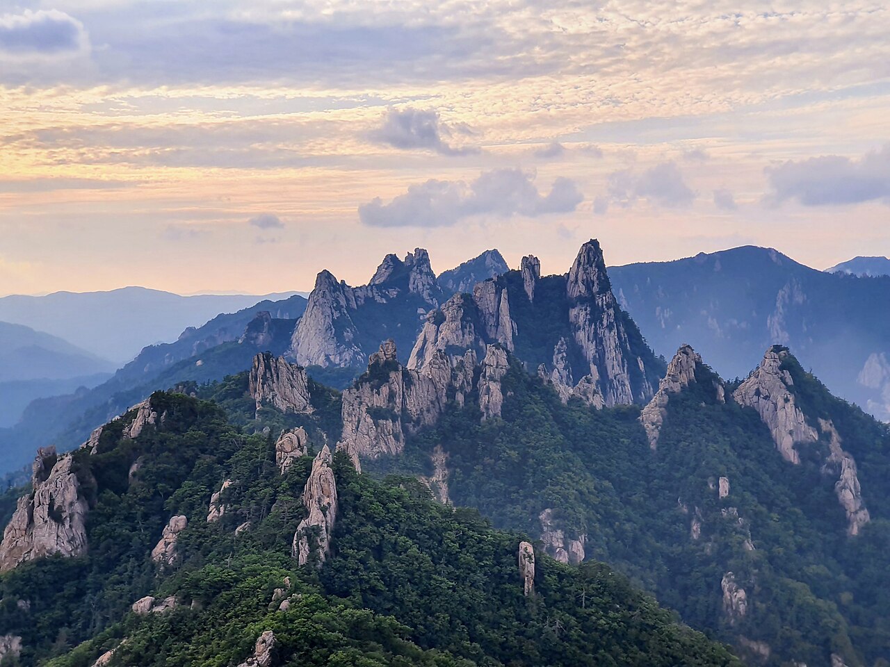
The scenery here is different in kind from Seoul's suburban mountains. Ulsanbawi — a cluster of six granite domes visible from the Sinheungsa valley — is the image most people associate with Seoraksan, and it earns the reputation. The two-hour climb up fixed-chain staircases brings you to a terrace of bare rock with views down the valley to the coast. On clear days in autumn, the sea is actually visible.
Daecheongbong (1,708 m), the summit, is a harder proposition: a full-day push from either the Osaek or Baekdam valley sides, involving steep rocky sections and some exposure. It rewards with a panorama that takes in the entire Taebaek range running north toward the DMZ. The trails are long enough that most day hikers never get close — you get genuine solitude above the tree line.
The autumn colour here arrives earlier than anywhere else in South Korea, typically the last week of September on the upper slopes. The combination of red maples against white granite and blue sky is the benchmark that other Korean autumn colour gets compared against. Plan around the second or third week of October for the lower valley colours.
Baekdamsa (백담사), the valley temple deep in the northern Outer Seorak zone, is a 6 km walk from the shuttle bus terminus along a flat river path. The temple itself is significant — Han Yong-un, the Buddhist poet and independence activist, lived here — and the walk through the boulder-filled stream valley is worth doing even without climbing.
Getting there
There is no train station in Sokcho. The standard approach from Seoul is by express bus from Seoul Express Bus Terminal (서울고속버스터미널, Gangnam, Line 3/7/9) or East Seoul Bus Terminal (동서울버스터미널, Gangbyeon, Line 2). Journey time is 2.5–3 hours depending on traffic; the Sokcho Terminal is the final stop. Fare is approximately ₩18,000–22,000 one way.
From Sokcho Intercity Bus Terminal, take local bus 7, 7-1, or the airport shuttle bus toward Seoraksan National Park entrance (설악산국립공원). The ride is about 15–20 minutes and costs ₩1,500 with T-money. Taxis from the terminal to the park gate run about ₩10,000–13,000.
For Baekdamsa (백담사) in Outer Seorak, take a bus from Sokcho toward Yongdae-ri (용대리) — about 45 minutes — then transfer to the national park shuttle bus (₩2,500 round trip) that runs to the Baekdam valley trailhead. Shuttle frequency varies seasonally; confirm times at the bus stop.
Kakao T and Naver Map both handle Sokcho area routes accurately. Most intercity buses to Sokcho can be booked via Kobus (www.kobus.co.kr) with an English interface.
At a glance
| Detail | Info |
|---|---|
| Elevation | 1,708 m (Daecheongbong) |
| Difficulty | 3–4 / 5 depending on route; Ulsanbawi 3/5, Daecheongbong 4/5 |
| Typical duration | Ulsanbawi: 4–5 hrs round trip; Daecheongbong: 8–10 hrs one way from Osaek |
| Best season | Autumn (late Sep–Oct); Spring (Apr–May) |
| National park | Yes — Seoraksan National Park |
| Entry fee | ₩3,500 adults (Inner Seorak / Sinheungsa gate) |
| Nearest city | Sokcho (express bus from Seoul, ~2.5 hrs) |
Safety
Emergency: dial 119. For English assistance call 1330 (Korea Tourism Hotline, 24 hours).
Weather changes fast above 1,200 m. The summit ridge can be in cloud while the valley is clear — check the Korea Meteorological Administration (kma.go.kr) mountain forecast the morning of your hike, not the city forecast.
Daecheongbong summit trail has sections of exposed ridge where a fall would be serious. Fixed chains and ropes are installed on the steepest parts, but confidence on steep terrain is required. This is not a beginner route. If you have not done multi-hour technical ascents before, target Ulsanbawi or the Biryong waterfall trails instead.
Winter closure: the national park closes certain high-altitude trails from December through March due to ice and avalanche risk. Check knps.or.kr for current closure maps before visiting in winter.
Summer: Seoraksan sees typhoon-related rainfall between July and September. Flash floods in the gorge valleys have caused fatalities. Do not attempt valley routes during or immediately after typhoon warnings.
Snakes: the Korean pit viper (살모사) is present in rocky lower slopes between May and October. Step carefully on trails with dense undergrowth.
Map
Food on the trail
The Sinheungsa trailhead area has a proper restaurant and snack village. 순두부찌개 (soft tofu stew) is the regional specialty — Sokcho soft tofu is famous across Korea and you'll see it everywhere. Plenty of options for 돌솥비빔밥 (stone pot bibimbap) and 산채정식 (mountain herb set meals) at ₩12,000–18,000 a head.
A GS25 convenience store operates near the park entrance. Stock up here with triangle kimbap, energy gels, and water before heading in — it's the last reliable food stop.
On the mountain: Yukdam Shelter (육담대피소) and Jungcheong Shelter (중청대피소) sell instant noodles and hot drinks during hiking season. Jungcheong is the main overnight shelter for Daecheongbong summiteers (reservation required via knps.or.kr). Shelter food is expensive and limited — treat it as emergency backup.
In Sokcho city (20 min by taxi): 아바이마을 (Abai Village) serves 아바이순대 (Abai blood sausage) and 오징어순대 — local specialties that are worth the short trip. The central market also has a row of raw seafood stalls (회) at reasonable prices.
Packing tips
- Water: 2 L minimum for Daecheongbong. 1 L is enough for Ulsanbawi.
- Hiking boots with ankle support: the Daecheongbong trails involve sustained rocky terrain. Trail runners are marginal; road shoes are not appropriate.
- Layers and wind shell: temperature at the summit is typically 10–15 °C colder than the valley floor. Even in summer, a fleece and windproof layer are needed above the tree line.
- Trekking poles: recommended for both the ascent and the long descent — the trails are long enough that knee fatigue is a real factor.
- Headlamp: if attempting Daecheongbong as a dawn summit, you will be starting in the dark from the shelter.
- Crampons / micro-spikes (Oct–Apr): ice appears on shaded sections well into spring. Rental at trailhead shops near the park entrance (approx. ₩5,000–8,000).
Best season
Spring (Apr–May): Snow clears from the upper trails through April. The valley azaleas bloom from mid-April and the lower forests green up quickly. Crowds are moderate. Good for full-day summit attempts once trails reopen.
Summer (Jun–Aug): The gorges are lush and the waterfalls (Biryong, Towangseong) run strong. Hot and humid at low elevation, cool above 1,000 m. Peak season for domestic tourists in late July and August — the park can feel crowded on weekends. Typhoon risk July–September.
Autumn (Sep–Oct): The best season by most measures. Upper slopes turn from late September; the Ulsanbawi and Sinheugnsa valley colours peak in mid-October. Clear, dry air and cooler temperatures. Accommodation in Sokcho books out on foliage-peak weekends — plan 3–4 weeks ahead.
Winter (Nov–Mar): Spectacular when snow-covered. Many high trails close December–March. The lower valley and Sinheungsa are accessible year-round. Ice on the upper chains makes Ulsanbawi genuinely dangerous without crampons.
Culture & history
Seoraksan (雪嶽山) translates as "Snow Peak Mountain" — a name earned by the whiteness of its granite in summer as much as its snowcap in winter. The mountain has been a sacred space since at least the Silla period, when Sinheungsa (신흥사) was founded, traditionally in 652 CE, making it one of Korea's oldest continuously operating temples.
The granite pinnacle of Ulsanbawi (울산바위) carries a legend that it originally belonged to Geumgang Mountain (금강산) across the peninsula in what is now North Korea. According to the story, the rocks gathered from across Korea to compete to be part of Geumgang, but Ulsanbawi arrived too late and stayed in Seorak instead. The legend encodes something real: Seoraksan and Geumgang share the same geological lineage, and before the division of Korea were considered a continuous alpine zone.
Baekdamsa (백담사) in Outer Seorak is inseparable from the life of Han Yong-un (한용운, 1879–1944), the Buddhist monk and poet who wrote "Silence of Love" (님의 침묵) here and was a central figure in the March 1st Independence Movement of 1919. The temple compound includes a memorial space for him.
The mountain was designated a UNESCO Biosphere Reserve in 1982, one of the first in Korea, in recognition of its extraordinary biodiversity — over 1,000 plant species and 260 vertebrate species have been recorded.
Frequently asked questions
›How high is Seoraksan?
Seoraksan rises to 1708 m above sea level.
›How difficult is hiking Seoraksan?
The difficulty of Seoraksan is rated 4/5 (Hard). Difficulty varies by trail, so check each course before you go.
›Do I need a reservation to hike Seoraksan?
No reservation is needed for the main trails on Seoraksan. Just check trail conditions before you set out.
›When is the best season to hike Seoraksan?
The best time to hike Seoraksan is Fall.
Have more questions? Ask the community on Connect Korea →