Why visit
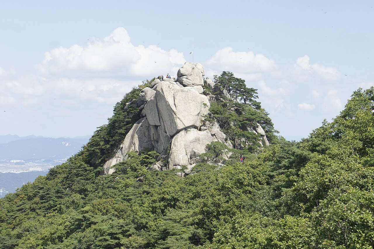
The upper ridge is the main event. Unlike Namsan or Achasan, Suraksan has genuine fixed-rope scrambles near the summit — bare granite with real exposure and no shade. The sense of being on a proper mountain rather than a city park hill is immediate once you clear the treeline around 500 m. Hikers training for Dobongsan or Seoraksan often run this route a few times first.
The waterfalls along the lower trails are a genuine draw, not a marketing exaggeration. The streams run strongest in April after snowmelt and again in late July through August after monsoon rain. Heungguksa temple sits at the base of the main valley trail, and the walk through its courtyard before hitting the steep section is a pleasant way to ease into the climb.
For Seoulites who want a traverse rather than an out-and-back, the ridge connects to Buramsan (불암산, 508 m) to the south. The combined route takes a full day and works neatly because subway access at both ends means you can start at Suraksan Station and finish near Hwarang Station on Line 6 — no car required and no retracing your steps.
Getting there
Take Seoul Metro Line 7 to Suraksan Station (수락산역). Exit 2 leads directly toward the western trailhead — it is about a 10-minute walk past restaurants and gear shops. From Gangnam, the ride takes around 45 minutes; from Nowon, about 15. Line 7 runs until roughly midnight.
For the northern approach from Uijeongbu, take Line 4 to Danggogae (당고개, the terminal station) and pick up local buses or walk 20 minutes to the northern trailhead. This is more useful if you are doing the full Suraksan–Buramsan traverse and want to start from the Uijeongbu side.
T-money cards work on all routes. Naver Map handles the routing accurately and has English-language directions.
At a glance
Elevation: 638 m Difficulty: 3 / 5 — rope sections and exposed granite near the summit Typical duration: 4–5 hours round trip Best season: April–May and October–November; hikeable year-round National park: No (municipal-managed) Entry fee: Free Nearest subway: Suraksan Station, Line 7
Safety
Rope sections require both hands — stow trekking poles before the fixed ropes above 500 m. Wet granite is far more slippery than it looks; avoid the upper ridge in rain or immediately after.
Ice builds on the upper rocks from late November through February. Micro-spikes or strap crampons are practical here; rental is available at shops near Suraksan Station exit for around ₩5,000–8,000.
The upper ridge has almost no shade. In summer (June–August), start before 08:00 and carry at least 2 L of water. Heat exhaustion is a real risk on the exposed section above 500 m.
Suraksan is not a national park — trail signage and emergency infrastructure are less developed than at Bukhansan. Pre-download an offline map before heading up. For emergencies, call 119 (mountain rescue, English relay available).
Map
Food on the trail
The street near Suraksan Station exit 2 has a reliable cluster of restaurants — sundubu jjigae (순두부찌개), doenjang jjigae (된장찌개), and grilled samgyeopsal (삼겹살) are the staples. These spots fill up with hikers on weekend mornings; arrive before 09:00 or after 13:00 to avoid queuing. Menus are Korean only — point at photos.
A GS25 or CU convenience store near the station handles pre-hike supplies: triangle kimbap, energy bars, canned coffee, and electrolyte drinks. Quick and cheap.
There are no food vendors above the trailhead. Heungguksa temple does not sell food. Carry everything you need from the station area.
Packing tips
Grip gloves — useful year-round on the fixed rope sections; insulated pair in winter. Water 1.5–2 L minimum — no water sources above the trailhead. Sun protection June–September — hat, SPF 50+, UV sleeves; the upper ridge has almost no shade. Micro-spikes or strap crampons November–February — rental available near station. Trekking poles — bring them, but stow before the upper scramble. Offline map — download before going; Suraksan has less signage than national park mountains.
Best season
April–May: Azaleas on the lower slopes in mid-April; snowmelt keeps the waterfalls at full flow. Temperatures 10–20 °C. Weekend crowds are real but manageable — start by 08:30.
June–August: The valley trail stays cooler, but the upper ridge is exposed and hot. Go early or save it for autumn. The falls run strong after monsoon rain.
October–November: The best season overall. Maple colour peaks in late October; cool dry air makes the granite scrambles comfortable. October weekends get busy.
December–February: Ice on upper rocks. Crampons needed. Fewer people, stark beauty, and the chance to see the falls partially frozen. A legitimate winter objective if you are geared up.
Culture & history
The name Suraksan (水落山) is unusually literal — "water falling mountain" — and the streams and cascades that earned it that name are still the defining feature of the lower trails. Korean mountains are often named for shapes or legends; a name this plainly descriptive is relatively rare.
Heungguksa (흥국사, "Prospering Nation Temple") on the lower slopes traces its origins to the Silla dynasty, though the current structures are later restorations. It remains an active monastery and functions as a quiet way-station for hikers before the steep upper section begins.
During the Joseon period, the mountain's position at the northeastern edge of the capital made it a retreat for scholars and monks who wanted distance from court life without completely leaving the orbit of Seoul. Several small hermitages (암자) established in that era survive in various states of repair. The mountain also sits within the shamanic geography of the Seoul region — certain springs and rock formations were historically used for ritual purposes connected to muism (무속신앙).
Frequently asked questions
›How high is Suraksan?
Suraksan rises to 638 m above sea level.
›How difficult is hiking Suraksan?
The difficulty of Suraksan is rated 3/5 (Moderate). Difficulty varies by trail, so check each course before you go.
›When is the best season to hike Suraksan?
The best time to hike Suraksan is Fall.
Have more questions? Ask the community on Connect Korea →