Why visit
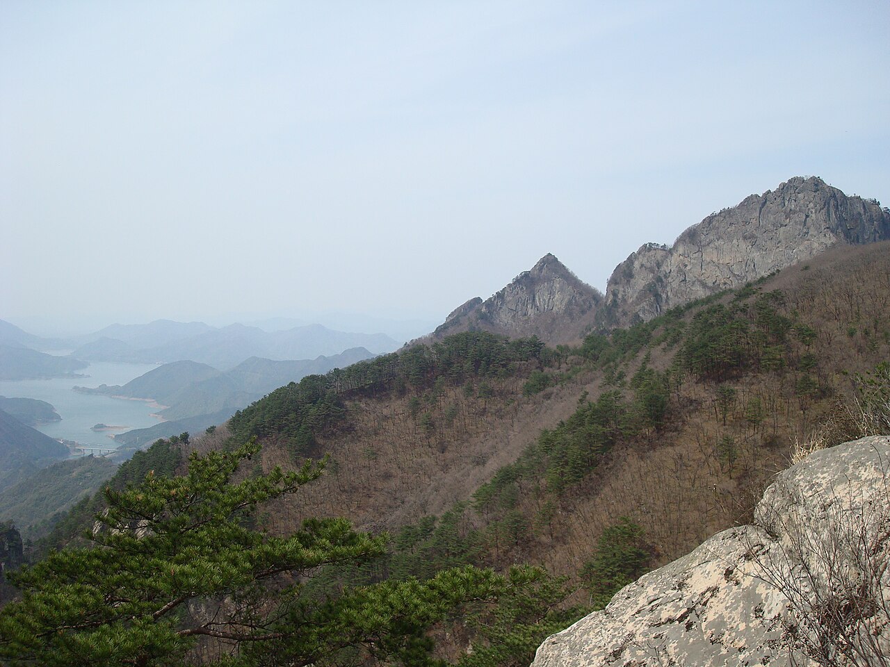
The cliff-and-reservoir combination is the main visual draw. Yeongbong's granite face drops almost vertically toward Chungju Lake — Korea's largest reservoir — and at golden hour in autumn the reflected colour in the water below is the kind of image that gets shared widely. It is less famous than Seoraksan, which means you are not competing with tripod queues for the shot.
The final approach to the summit is genuinely hard. The last 300–400 metres involves iron ladders and steep bolted staircases fixed into the rock face. People with serious vertigo should stop at the last viewpoint. For everyone else, the 360-degree granite-top panorama at the top — reservoir, Sobaek ridgeline, distant peaks — is worth the shaking legs on the way down. Round trip from Songgye entrance runs 5–7 hours.
At the Mireuk-ri trailhead, the Mireukni Stone Buddhist Temple Site (미륵리 석불사지, Historic Site No. 317) sits almost undisturbed — a Goryeo-era standing stone Buddha roughly 10 metres tall, a five-storey pagoda, stone lanterns, all still in place. It is five minutes off the trailhead and has none of the reconstructed gates and gift shops of more touristified temple sites.
Getting there
The gateway is Chungju (충주). From Seoul, take the Jungang Line train from Cheongnyangni Station (청량리역) — not Seoul Station, which does not connect to this line — to Chungju Station. About 1 hour 40 minutes, around ₩13,000–16,000. From Chungju Intercity Bus Terminal, take a local bus toward Songgye Valley (송계계곡). Buses run several times a day but are infrequent; check the last bus time (typically around 17:30–18:00) before heading up the mountain. A taxi from Chungju to the Songgye trailhead costs around ₩25,000–30,000, which makes sense for a group. Express buses from Seoul Nambu Terminal to Chungju take about 1.5 hours and cost around ₩10,000.
At a glance
Elevation: 1,097 m (Yeongbong summit) Difficulty: 4 / 5 — steep iron ladders and staircases; vertigo risk on upper section Typical duration: 5–7 hours round trip to Yeongbong from Songgye entrance Best season: October (foliage and cliff-lake views); January–February (snow on granite) National park: Woraksan National Park (월악산국립공원) Entry fee: Free as of 2024 — confirm at gate; parking fees apply
Safety
Trail closures: Fire-prevention closures run roughly February 1–May 15 and November 1–December 15. The Yeongbong summit section can be closed separately during storm warnings. Verify the day before at the KNPS Woraksan page or call 1330 (24 hours, English available).
The iron ladder sections: The final approach to Yeongbong involves steep fixed ladders on exposed rock. After rain these are wet and slippery; from November onward they ice. Anyone with significant vertigo should turn back at the last viewpoint — there is no bypass. Rangers enforce crampons from November onward.
Cell signal drops above 700 m and is essentially gone near Yeongbong. Pre-download offline maps before leaving Chungju.
Emergency: 119. Ranger posts at Songgye and Deokju entrances.
Map
Food on the trail
Restaurants along the Songgye Valley road serve hikers from around 07:00–08:00 — doenjang jjigae (된장찌개), pajeon (파전), sanchae bibimbap (산채비빔밥), grilled pork. Solid, filling stuff. Most close by early evening.
The Deokju and Mireuk-ri entrances have fewer options — stock up in Chungju if starting from those gates.
Nothing on the mountain itself. Bring lunch and at least 1.5 litres of water. There are streams in the lower Songgye Valley but drinking untreated water from them is not worth the risk.
Chungju city centre has plenty of CU and GS25 branches. Buy snacks before boarding the bus.
Packing tips
Trekking poles with wrist loops — the descent from Yeongbong is harder on the knees than the climb; poles earn their weight here. Microspikes October–November; full crampons December–March — the ladders ice early; rangers may turn you back without them from November. Wind layer and gloves — the exposed summit is significantly colder and windier than the forested lower trail even in autumn. Lunch and 1.5 L water — no resupply on the mountain. Offline map — download before leaving Chungju; signal drops significantly above mid-mountain. Cash — parking machines and trailhead diners often cash only.
Best season
April–May: Azaleas and wildflowers on the granite slopes from late April. Spring fire closures restrict part of the summit access — check before going.
June–August: Songgye Valley's stream corridor stays cool. The reservoir turns vivid blue-green in July and August. The summit is fine in the morning before heat builds.
October: Peak season. Foliage crests around October 10–20 on the upper slopes. The cliff face reflected in the reservoir at that time is the image most people have of Woraksan. Weekend crowds at Songgye are real.
January–February: Snow on white granite makes for a stark, distinctive look. The ladder sections ice badly — crampons and an early start are non-negotiable. Much fewer people. The reservoir views under snow are extraordinary.
Culture & history
The name Woraksan (月岳山) comes from the idea that the summit of Yeongbong, sitting above the dark reservoir, cradles the rising moon against the eastern ridge. It is one of those names that makes more sense the first time you see it from below at night. Joseon-era poets wrote about it.
At the Mireuk-ri trailhead, the Mireukni Stone Buddhist Temple Site (미륵리 석불사지, Historic Site No. 317) is among the most compelling open-air Buddhist ensembles in central Korea. A standing Maitreya Buddha roughly 10 metres tall, carved during the Goryeo dynasty, anchors the site with a five-storey pagoda and stone lanterns still mostly in position. The site feels undisturbed in a way that heavily restored temple complexes do not.
Deokjusa temple (덕주사), reached from the Deokju entrance, shelters a Goryeo-period cliff-face Buddha carved directly into the rock above the courtyard. The natural setting does most of the work.
Woraksan National Park was designated in 1984 and covers about 287 km² across Chungcheong provinces.
Frequently asked questions
›How high is Woraksan?
Woraksan rises to 1097 m above sea level.
›How difficult is hiking Woraksan?
The difficulty of Woraksan is rated 4/5 (Hard). Difficulty varies by trail, so check each course before you go.
›Do I need a reservation to hike Woraksan?
No reservation is needed for the main trails on Woraksan. Just check trail conditions before you set out.
›When is the best season to hike Woraksan?
The best time to hike Woraksan is Fall.
Have more questions? Ask the community on Connect Korea →